ENG: I show a few photos on the Dutch hiking site on my Fraser Island adventure walk. See link in the exhibition menu on my website.
FRA: Certaines photos de ma marche sur l'île de Fraser sont exposées sur le site de randonnée Hollandais. Voir le lien dans la partie exposition sur mon site web.

Friday, May 18, 2007
Monday, April 09, 2007
Brief news
ENG: My feet do get better, I feel 3/10 toes and took my weight back. I worked a bit on the website and started a 6 months training into computer network administration (MS certification in Windows 2003 server + Linux)
FRA: Mes pieds vont mieux, j'en sens 3/10 et j'ai repris mon poids. J'ai un peu travaillé sur le site et j'ai commencé une formation d'administrateur réseaux windows 2003 serveur (certifications Microsoft)et Linux.
FRA: Mes pieds vont mieux, j'en sens 3/10 et j'ai repris mon poids. J'ai un peu travaillé sur le site et j'ai commencé une formation d'administrateur réseaux windows 2003 serveur (certifications Microsoft)et Linux.
Tuesday, February 20, 2007
Back to Belgium... alive
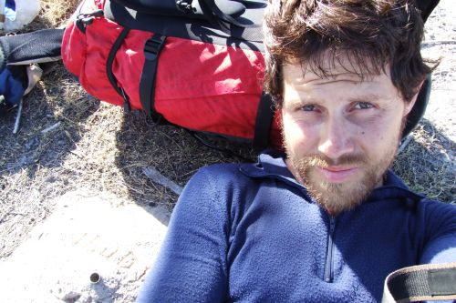
 My adventure in Tasmania was very dangerous and lasted longer than the 40 expected days as I walked for 49 days. I started with 49 kg in my backpacks. I lost 10 kg. Because I was so late, my friend -and Australian adventurer- Chris Bray (on my right) was worried. He did the right thing and checked -amongst others- if I had used my EPIRB (Emergency Position Indicating Radio Beacon). I called just a few hours after to tell him I was finished and alive.(see his email here below).
Thanks Chris !! Thanks Peter !
Sent: To peter at Epirb hire
Sent: Wednesday, 7 February 2007 1:30 PM
Subject: Louis-Phillipe is OK! He Just Finsihed!
Hi All,
I just got a call from Louis-Philippe 2min ago, using the ranger's phone at the end of the South Coast Track - He's finished - He sounds incredibly weak and said he's "just happy to be alive".
Thanks very much for all involved and sorry for any hassle caused by starting to raise the alarm, I think it was the right thing to do. I'm glad he's ok! He'll have a hell of a story to tell.
All the best,
Chris
Now back in Belgium since 1 week, I send CVs to find a job.
I recover from a very bad infected leg -the infection spread to both feet- and frostbites (not that bad but hurts) on all toes and fingertips. I gain weight slightly but have troubles to walk properly, I cannot even run as my mind pilots small atrophied muscles. By the way, happy 2007 to all of you!
----
Retour en Belgique...vivant
Ma dangereuse aventure en Tasmanie a duré plus des 40 jours prévus. J'ai commencé avec 49 kg dans mes sacs et j'ai peiné pendant 47 jours. J'ai perdu 10 kg. Puisque j'étais en retard, mon ami aventurier Chris Bray, inquiet sans nouvelles, a tenté de savoir -entres autres- si j'avais déclenché ma balise de détresse (voir message plus ici haut). Quelques heures plus tard, j'appelais pour lui dire j'étais au bout et vivant.
Merci Chris !! Merci Peter !
A présent en Belgique depuis 1 semaine j'ai déjà envoyé des CVs pour du travail.
Je soigne une sale infection à la jambe -qui s'est propagée aux 2 pieds-et mes légères engelures aux orteils et bout des doigts (pas trop grave). Je reprend doucement du poids mais je marche difficilement et ne peux pas encore courir à cause aux petits muscles atrophiés qu'il me reste. Au fait, bonne année 2007 à vous tous !
My adventure in Tasmania was very dangerous and lasted longer than the 40 expected days as I walked for 49 days. I started with 49 kg in my backpacks. I lost 10 kg. Because I was so late, my friend -and Australian adventurer- Chris Bray (on my right) was worried. He did the right thing and checked -amongst others- if I had used my EPIRB (Emergency Position Indicating Radio Beacon). I called just a few hours after to tell him I was finished and alive.(see his email here below).
Thanks Chris !! Thanks Peter !
Sent: To peter at Epirb hire
Sent: Wednesday, 7 February 2007 1:30 PM
Subject: Louis-Phillipe is OK! He Just Finsihed!
Hi All,
I just got a call from Louis-Philippe 2min ago, using the ranger's phone at the end of the South Coast Track - He's finished - He sounds incredibly weak and said he's "just happy to be alive".
Thanks very much for all involved and sorry for any hassle caused by starting to raise the alarm, I think it was the right thing to do. I'm glad he's ok! He'll have a hell of a story to tell.
All the best,
Chris
Now back in Belgium since 1 week, I send CVs to find a job.
I recover from a very bad infected leg -the infection spread to both feet- and frostbites (not that bad but hurts) on all toes and fingertips. I gain weight slightly but have troubles to walk properly, I cannot even run as my mind pilots small atrophied muscles. By the way, happy 2007 to all of you!
----
Retour en Belgique...vivant
Ma dangereuse aventure en Tasmanie a duré plus des 40 jours prévus. J'ai commencé avec 49 kg dans mes sacs et j'ai peiné pendant 47 jours. J'ai perdu 10 kg. Puisque j'étais en retard, mon ami aventurier Chris Bray, inquiet sans nouvelles, a tenté de savoir -entres autres- si j'avais déclenché ma balise de détresse (voir message plus ici haut). Quelques heures plus tard, j'appelais pour lui dire j'étais au bout et vivant.
Merci Chris !! Merci Peter !
A présent en Belgique depuis 1 semaine j'ai déjà envoyé des CVs pour du travail.
Je soigne une sale infection à la jambe -qui s'est propagée aux 2 pieds-et mes légères engelures aux orteils et bout des doigts (pas trop grave). Je reprend doucement du poids mais je marche difficilement et ne peux pas encore courir à cause aux petits muscles atrophiés qu'il me reste. Au fait, bonne année 2007 à vous tous !
Friday, December 15, 2006
Wild Mountains of Tasmania
(21/12/2006-07/02/2007)
The Tasmanian World Heritage Area (WHA)
The Tasmanian wilderness is an area in the world that is extremely fragile and therefore must be protected. It has obtained the most criteria ever to be ranked WHA by the UNESCO. Hiking in there is to be surrounded by almost untouched nature. It's pure wilderness.

Hike across the entire Tasmanian wilderness starting north from Cradle Valley and arriving at Cockle Creek on the South coast. Underway climb a list of 15 MUST climb mountains and if possible as much of the 30+ other mountains in the same area. The adventure is solo and unsupported (no food drops, buy nothing underway, carry garbage).
The 15 must climb mountains
Cradle, Barn Bluff, West Pelion, Ossa, Gould, Olympus, Rufus, King William 1+2+3, Anne, Hesperus, Orion, Federation Peak and La Perouse. The nice to have summits are: Achilles, Thetis, Massif, Hyperion, Eros, Geryon North, Minotaur, Byron, Hugel, Wright, the Thumbs, Mueller, Bowes, Eliza, Lot, Sarah Jane, Hayes, Pegasus, Capricorn, Columbus, Taurus, Aldebaran, Scorpio, Phoenix, West Portal, Bobs, Precipitous Bluff and Pindars peak.
The preparation
I plan the yellow path, which is a trade-off between time and distance to reach all 15 mountains. It links official tracks with off-track bushbashing in the dense vegetation. The bushwalking forum and several highly experienced Tasmanian walkers helped me to decide for this path, including escape options in case of injury. Several rivers must be crossed swimming or wading. It is forbidden to light up fire, hunt and pick up plants in the WHA so all food must be carried from the start. I plan 40 days of food which is the maximum weight and volume I can carry.
Two weeks before leaving, I eat a lot of fat like full spoons of butter, peanut butter, fries... I expect to loose between 5 and 15 kg.
Brief adventure log - Download here excel file
It's hard to summarize 49 days of effort in the wilderness. I rather put here some conclusions about the trip. I have put some more day to day details on my blog and panoramic photos. These photos represent why I’m going to these places. The beauty for my eyes is above the pain, the hunger, the cold and the loneliness.
I started with 49 kg on my back (food, equipment) and possibly did the longest unsupported walk in Tasmania.
I started with 49 kg on my back (food, equipment) and possibly did the longest unsupported walk in Tasmania.


On the 21-01-2007, I woke up with a swollen calf (leg) the weather was bad with thick clouds and it was still raining. I was very close to Federation peak. I stayed in my tent the entire day. The next day I saw some sun through and climbed the peak. I only had 1 MUST climb mountain left, Mt La Perouse. To reach it, I have to go down the Eastern Arthurs range, find the Lake Sydney track to Mt Bobs. I entered the last off-track part.
The calf remained swollen during the 3 last weeks of the trip. It slowed me down and I decided not to go to Mt La Perouse but to escape and save my life ASAP (lack of food) by following the Salisbury River, the New Lagoon River to the south coast. While saving my life, my GPS broke. If I was not following the river, I would have been lost and probably dead. When I reached the south coast track, which I walked in 2004, I knew I would live. Five minutes after seeing the first humans in 13 days I cried because I was speechless. I finished at Cockle creek and 36 hours later I flew from Hobart to Sydney and 3 days later I was back in Belgium. I had lost 10 kg of my body weight.
The calf remained swollen during the 3 last weeks of the trip. It slowed me down and I decided not to go to Mt La Perouse but to escape and save my life ASAP (lack of food) by following the Salisbury River, the New Lagoon River to the south coast. While saving my life, my GPS broke. If I was not following the river, I would have been lost and probably dead. When I reached the south coast track, which I walked in 2004, I knew I would live. Five minutes after seeing the first humans in 13 days I cried because I was speechless. I finished at Cockle creek and 36 hours later I flew from Hobart to Sydney and 3 days later I was back in Belgium. I had lost 10 kg of my body weight.


I was lucky and happy to be alive. The injury (swollen calf) was bad. I had the early stage of the Trench Foot disease. In Tasmania you cannot beat the wet, the mud off-track. I was proud of making the decision to abandon the last summit; it’s a sign of courage and maturity to finish your adventure when your life is at stake. To cure the trench foot, I ate 16 pills per day during 2 months and the feeling in my toes came almost back to normal after a year.
I have 40 pages of diary, hopefully I can write this in a book when I’ll find the time. If it’s a story you’d like to read, drop me a line to encourage me to start.


The Aussie bushwalking googlegroup people who have helped me to prepare this trip. Specials thanks to Chris Bray, Roger Caffin, John Chapman, Roger Chao and all Tassie rangers.
Sponsors

This gear shop in Sydney gave me advices on dehydrated meals and equipment. The manager allowed me to use his GPS.

EPIRBhire supplied me with a PLB (personal locator beacon) to be found in case of emergency.

This is the website to the dehydrated food. Very tasty and containing necessary vitamins to keep my body healthy. Lightweight and not bulky.
Les Montagnes Sauvages de Tasmanie
(21/12/2006-07/02/2007)
La région sauvage de la Tasmanie, patrimoine mondiale
L'état sauvage de la Tasmanie est une zone de ce monde extrêmement fragile et il faut la protéger. La région a obtenu le plus critères jamais reçus pour devenir patrimoine mondiale de l'UNESCO. Y faire du trekking c'est se retrouver entouré d'une nature vierge de toute présence humaine.
Traverser la région sauvage de la Tasmanie en partant du Nord de la vallée de Cradle et rejoindre la côte Sud à Cockle creek. En route gravir 15 sommets obligatoires et un maximum d'autres sommets d'une liste d'au moins 30 sommets des régions traversées. L'aventure est solo et sans support (sans ravitaillement, sans achat de matériel et transportant mes déchets)
Les 15 sommets à gravir: Cradle, Barn Bluff, West Pelion, Ossa, Gould, Olympus, Rufus, King William 1+2+3, Anne, Hesperus, Orion, Federation Peak and La Perouse.
Les sommets facultatifs: Achilles, Thetis, Massif, Hyperion, Eros, Geryon North, Minotaur, Byron, Hugel, Wright, the Thumbs, Mueller, Bowes, Eliza, Lot, Sarah Jane, Hayes, Pegasus, Capricorn, Columbus, Taurus, Aldebaran, Scorpio, Phoenix, West Portal, Bobs, Precipitous Bluff et Pindars peak.
La préparation
Ma route de départ est la ligne jaune, qui est optimisée pour accéder aux 15 sommets des montagnes. Cette route relie des chemins de randonnées officielles avec de la forêt dense et quasi impénétrable. Plusieurs randonneurs chevronnés pour la Tasmanie m’ont aidé à définir cette route et les options pour s’échapper en cas de blessure. I faut traverser certaines rivières à la nage ou à gué. Il est interdit de faire du feu, de chasser et de cueillir des plantes dans le patrimoine mondial, il faut donc transporter tous ses vivres depuis le départ. J’estime avoir besoin de 40 jours ; ce que représente aussi le maximum de volume et de poids que je puisse transporter.
Durant les deux semaines qui précèdent le départ, je grossi en mangeant du beurre pur et du beurre de cacahouètes, frites… Je vais probablement perdre entre 5 et 15 kg.
Bref carnet d'aventure - Téléchargez ici fichier Excel
Il n’est pas évident de résumer 49 jours passée dans une forêt sauvage. Je vous donne plutôt quelques conclusions sur ce périple. Sur mon blog vous trouverez plus de détails (uniquement en Anglais) et des photos panoramiques. Ces photos représentent le pourquoi des lieux que j’aime découvrir, une beauté pour les yeux qui surpasse toute souffrance mentale et physique du corps, la faim, le froid et la solitude.
Je suis parti avec 49 kg dans mon sac à dos (vivres, équipement) et j’ai probablement fait la plus longue marche sans ravitaillement en Tasmanie.
Le 21-01-2007, je me réveille avec un mollet gonflé. Les nuages sont gros, la brume m’encercle et il pleut averse. Je suis pourtant si près de Federation peak. Je ne sors pas de la tente de toute la journée. Le jour suivant, le soleil s’est montré modestement et j’ai su gravir ce fameux sommet. Il me resta seulement 1 sommet de ma liste, le mont La Pérouse. Pour l’atteindre, il faut descendre de la chaîne des Eastern Arthurs; trouver le lac Sydney et le chemin menant au mont Bobs. A partir de la j’entre dans la dernière partie hors sentir la plus difficile de l’île.
Le mollet resta gonfle pendant les 3 dernières semaines du périple. Cela m’a ralenti et j’ai décidé d’abandonner l’ascension de La Pérouse. J’ai préfère penser à m’échapper et à sauver ma vie au plus vite (les vivres me manquent) en suivant la rivière Salisbury, puis la rivière New Lagoon vers la côte sud. L’humidité a eu raison de mon GPS. Si je ne suivais pas le cours d’eau, je me serai certainement perdu et j’aurai péri. Lorsque j’ai atteint le chemin du South coast, cette randonnée que j’avais parcourue en 2004, je savais que je vivrai. A peine avoir rencontré les premiers humains depuis 13 jours, je fondis en larmes car l’émotion me rendait sans voix. J’ai terminé à Cockle creek et 36 heures plus tard je quittais la Tasmanie pour Sydney et j’atterrissais en Belgique 3 jours plus tard. J’avais perdu 10 kg de ma masse corporelle.
J’étais chanceux et heureux d’être vivant. L’infection au mollet était le début de la maladie du pied des tranchées. En Tasmanie, on ne peut battre l’humidité, la boue en hors-piste. J’étais fier finalement d’avoir eu le courage de prendre la sage décision de ne pas foncer vers le dernier sommet. Je crois que c’est une preuve de maturité de faire ce genre de choix lorsque notre vie est en jeu. Pour guérir de la maladie du pied des tranchées, je me suis gave de 16 pilules pendant 2 mois et la sensation perdue dans mes orteils est revenu à son état quasi originel après 1 an.
Mon carnet d’aventure est riche de 40 pages et j’espère trouver le temps d’écrire un bouquin lorsque je trouverai du temps. Si le récit complet vous intéresse, merci de m’en faire part en m’envoyant un petit mot pour m’encourager à commencer.
Aux personnes du newsgroup de bushwalking Australien qui m'ont aidé à préparer l'aventure. Merci spécial à Chris Bray, Roger Caffin, John Chapman, Roger Chao et les rangers de Tasmanie.
Sponsors
Ce magasin d'équipement à Sydney m'a conseillé en repas lyophilisés et équipement. Le gérant m'a prêté son GPS.
EPIRBhire m'a prêté une PLB (balise de détresse personnelle) pour être retrouvé en cas d'accident.
Site web des repas lyophilisés. Léger et peu encombrant.
Wednesday, November 22, 2006
Accident
ENG: Did somthing stupid a few days ago... now I have a broken rib (or more) but apparently nothing bad inside (lungs, kidneys, spleen) even if some blood was found in the urine. I just stay calm for now.
FRA: Acrobatie stupide il y a qqs jours... j'ai une cote cassee (ou plusieurs) mais apparemment rien de grave a l'interieur (poumons, rate, reins) meme si on a retrouve du sang dans mes urines. Je reste donc calm.
FRA: Acrobatie stupide il y a qqs jours... j'ai une cote cassee (ou plusieurs) mais apparemment rien de grave a l'interieur (poumons, rate, reins) meme si on a retrouve du sang dans mes urines. Je reste donc calm.
Thursday, November 16, 2006
57.3 Megapixel Panoramic Photo

Statistics:
17 photos of 9 megapixels
180 degrees view from Mt Giles Summit II to Ormiston Pound. Background: Mt Sonder, Razorback and Zeil.
2 hour calculation with Pentium4 2.8 Ghz 512 RAM, intermediary file size 1127 Mb.
This photo is thus 2 times longer and higher than this one printed last year (also Ormiston Pound but from an other angle):
Larapinta panoramic photo
Monday, November 06, 2006
Aussie Adventurer
ENG: Last week, and thanks to Peter from www.EPIRBHIRE.com (I rented a satellite emergency distress beacon from him), I met Chris Bray.
Chris is a young Australian adventurer with lots of projects. To know more about him : www.ChrisBray.net and/or www.1000hourday.com
I am updating the website but working more on the panoramic photos of the Outback and Fraser Island adventures.
FRA: La semaine derniere, et grace a Peter de www.EPIRBHIRE.com (a qui j'ai loue une balise satellite de detresse), j'ai rencontre Chris Bray.
Chris est un jeune aventurier Australien avec beaucoup de projets. Pour en savoir plus sur lui: (voir liens plus haut)
Je travaille a la mise a jour du site web et plus particulierement aux photos panaoramiques des aventures dans l'outabck et sur l'ile de Fraser.
Wednesday, October 18, 2006
Back from Adventures
FRA:
Parti le 01/09/2006 vers Alice Springs,je suis revenu a Sydney le 14/10.
Qu'ai-je fait pendant ce temps la?
Du 04/09 au 15/09 j'ai marche dans la partie la plus montagneuse de l'Outback Australien. J'ai parcouru environ 330 km seul et sans assistance et gravi les Montagnes suivantes au passage:
* Zeil 1531m
* Razorback 1274m
* Sonder 1380m
* Giles 1389m
Petit passage dans le journal locale d'Alice Springs, repos et assister a la regatte Henley on Todd. Cette regatte se fait dans le lit d'une riviere assechee, on y a enleve le fond des bateaux, kayaks, baignoire, avirons... et cela se transforme en course a pied populaire. Drole!
Vol suivant vers Cairns, ou je me fait enfin un didjeridoo avec un aborigene. Je suis descendu jusque Sydney en autostop et au passage:
* Entrainement a la rando sur l'ile de Hinchinbrook,32km.
* croisiere de 3 jours sur le Whitsundays
* rando des Whitsundays
et la 2eme aventure ou j'ai traverse du sud au nord la plus grande ile de sable au monde (01->10/10/2006). Un gigantesque banc de sable nomme Ile de Fraser. En tres grande partie couvert de jungle et de lacs d'eau douce. Je m'y suis aventure sur 250 km dont 3 jours en pleine jungle ou parait-il personne ne sait ballade seul en 30 ans. J'ai laisse pousse la barbe...
ENG:I flew from from Sydney to Alice Springs on the 01/09/2006 and just came back 3 days ago. What have I done in 6 weeks?
From 04/09 to 15/09 I walked in the most mountaineous part of the Australian outback.
I walked about 330km solo and unassisted, climbing the following Mountains:
* Zeil 1531m
* Razorback 1274m
* Sonder 1380m
* Giles 1389m
I had a small article in Alice Springs' newspaper, and the day after finishing the adventure, rested and enjoyed the Henley on Todd dry regatta. It's a lot of fun to see the bottomless boats and people running with it.
I flew to Cairns, made a didgeridoo with an aboriginal, went for a walk on Hinchinbrook Island.
Actually I hitch hiked all the way from Cairns to Sydney, with a few stops:
* Walked the Thorsborne trail on Hinchinbrook Island.
* Whitsundays to do a 3 day sailing cruise, and the whitsundays great walk.
I went then to my second adventure(01->10/10/2006): the crossing of Fraser Island from South to North.
It's the biggest sand island on earth, a lot of sand covered by vegetation and fresh water lakes. I covered 250km and was apparently one of the first in decades to walk 3 day in the most northern tip of the island where it's a thick jungle.
And yes I have a 6 weeks beard
Monday, October 09, 2006
The Great Sand Island
01-09/10/2006

The project.
The biggest sandbar on earth is an island called K’gari (before 2021: Fraser island). The best way to see its beauties is to walk on a Great Walk. (See map from Dili Village to Happy Valley), which I wanted in May 2005. In Brisbane, I went to the Parks and Wild Life office to ask the rangers about the usual track information. They gently said it was forbidden (actually highly discouraged) to walk alone on the giant sandbar. The island's dingoes, these wild dogs that are a crossbreed between a wolf and a Labrador, are full-blood and are extremely dangerous. They occasionally attack humans and there was a fatality in April 2001. I tried to explain I was trained and that I was going to be careful. In vain, after a 20 minutes talk with the local rangers and a phone call to the head ranger on the island, I quit the idea of this Great Walk to go for a less dangerous activity: 5 days on a live-aboard on the outer Great Barrier Reef with the main attraction being diving amongst 40 mid-sized sharks.
In 2006, I decided to come back to Australia with my adventurous spirit far from the too safe advices of the rangers. This time I want to walk across the entire length of the island from South to North. This is an adventurous project as I will go unsupported (alone, no external help and no food drops) while passing through the most beautiful gems of the island. This should be quite easy. The main dangers are the dingoes, snakes and not to find water in the remote Northern part of the North of Orchid beach. This area is the most difficult part as it's only visited on the coast by 4WD driving to the lighthouse.
K’gari, the world's biggest sand island.
K’gari Island is 123 km long and 40 km at its maximum width. Fauna and flora are diverse and settled on the sand island. Dense and very impenetrable vegetation is present almost everywhere on the sand surface. The main attractions of K’gari are its perched fresh water lakes and coloured sands often seen near sandblows. An unending beach on the East coast is as highway for 4WDs. Even if the width of the beach is 3 (low tide) to 40m, accidents happen.
The preparation.
The fatal attack by two dingoes happened on an 8 year old boy. After reading a dozen documents on the dingo's behaviour, etc... The brief conclusions are:
- There are 300 dingoes on a 1500 km2 island - The probability that an adult gets attacked by several wild dogs is very low (you must be very lucky!)
- I am aware of the danger and I can defend myself with my 2 walking sticks and I keep a tent peg as dagger in my pocket.
- I follow all the advices: don't feed, don't get close, stand in front not show my back, don't provoke and defend aggressively if attacked.
The HEMA map 1:130.000 is plenty enough to walk on the island because the Great Walk track is marked and following the beach is easy. It can be a bit tricky to find the fastest walking track on the sandy bottom made by the 4WD.
Brief adventure log - Download here excel-file
I leave the hostel and hitch hike towards Inskip point. One hour later I am on the barge that drops all vehicles and I on the top South of K’gari island. Carrying 20 kg, I start walking North on a closed 4WD track towards Dili Village. I am astonished by the easiness of the walk on compact sand covered with decomposing vegetation. As usual, walking alone lets me see many animals like goannas over 80cm long. At Dili Village I follow the Great Walk and reach Lake Boomanjin as planned just before sunset. The next morning, I watch the sun rising in the mirror of the lake. A color scene I enjoy with my camera.


Without entering too much into details, the next walking days on the Great Walk are the same: easy walking trying to cover an average of 30km per day. Each night I talk to bushwalkers. We exchange experiences and they tell me they want to know if I will make it. One night, I reach the valley of the giants in the complete darkness. I interrupt a group of guided walkers who are just finishing their dessert. They propose me their Indian curry. I explain that my adventure is unsupported and decline the offer. I join their table and eat my food while they keep trying to offer me a dessert. I don’t refuse their smiles and kind encouragements.
Once the Great Walk is finished, I only have to follow the sand highway going north. I pass 4WDs, buses and even planes. Some drivers are quiet curious and slow down to my side to propose me a lift further. I kindly refuse any lift! I make a small wave with my finger to each vehicle passing me. Every Australian sent this back to me. This is a sign Australians answer with pleasure. This way of greeting is often used in the country where people are isolated.


During several meetings with aboriginal Queenslanders, I was told not to bathe in the sacred lakes of K'gari’s northern tip. A kind of curse but at the Dundubara aboriginal camping, I ask the owner about these warnings. She tells me actually only aboriginal people cannot bathe in these lakes and compliment me to be a different white man as I travel by foot. I promise her I won't swim in order to stay as close as possible to aboriginal traditions and beliefs. I am suddenly invited by a young boy on a private aboriginal path leading me back to the beach.
Indian head is the only rock formation on the island. It's where one can have a nice lookout over the junction between 2 colours of the ocean. The view from the top is incredible. There I take my longest break in order to spot whales, dolphins, sharks, turtles and rays. I am staring at the ocean when suddenly a completely unexpected event happens: a manta ray goes into a wave to take a jump out of the water. The entire body flew over the water for less than a second but it was just amazing. I understood why in the past they were called the devils of the seas by the first witnesses of this wonder.


At Orchid beach, I leave my contact details to Don, the manager of the little deli shop. I tell him I wish to finish my walk inland following the track I spotted on satellite images. He tells me there was a road before used by the army but it was closed for over 20 or 30 years. It must be overgrown by now and thus it would be very difficult to find something. I understood his concern and decided to plan 2 days instead of 1 to walk the remaining 30 km. I start searching for the forgotten road around Ocean Lake. An Aussie tourist tells me he’s coming here for decades and never heard about a road leading inland to the lighthouse. I go with my compass… and discover that the start of the track is just behind the toilets lake. These are blocking its access.
I follow the abandoned track and make a slow progression. As expected, it’s slow going through swampy vegetation as the track is swept by plants and trees. I got often lost and the only way to find water (a lake) is to climb the trees on the top of the hills. I discover that most of the lakes are completely dry, which forces me to drink slowly. The good side is that walking on dry and hard crust is easy.


Several places are real jungle where I have to pass through bush and thick vegetation woven by vines. Without machete, I end up either walking 50cm above the ground, either doing Thai boxing using my legs to untangles them from vines and small trees. My skin rapidly peels off and I bleed everywhere under my pants. After 3 days of dense jungle and pain, I haven’t much food and water left. The rage allows me to forget the pain and continue at a steady pace because I know I’m close to the beach on the Northern tip of the island.
I finally reach the beach, which makes me feel free and lightweight. From there it's an easy walk on the hard sand to the lighthouse and the Sandy Cape. The reward after such efforts is to finally accept a lift in a 4WD. I am pleased by the feeling of being the first to photograph these places almost unexplored. Three days have passed; Don was worried about me and offers me a fresh beer. In the distance we hear some tourists talking about a lonely guy they saw walking a few days ago along the island's beach.