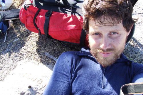
ENG: Last week, and thanks to Peter from www.EPIRBHIRE.com (I rented a satellite emergency distress beacon from him), I met Chris Bray.
Chris is a young Australian adventurer with lots of projects. To know more about him : www.ChrisBray.net and/or www.1000hourday.com
I am updating the website but working more on the panoramic photos of the Outback and Fraser Island adventures.
FRA: La semaine derniere, et grace a Peter de www.EPIRBHIRE.com (a qui j'ai loue une balise satellite de detresse), j'ai rencontre Chris Bray.
Chris est un jeune aventurier Australien avec beaucoup de projets. Pour en savoir plus sur lui: (voir liens plus haut)
Je travaille a la mise a jour du site web et plus particulierement aux photos panaoramiques des aventures dans l'outabck et sur l'ile de Fraser.

Monday, November 06, 2006
Wednesday, October 18, 2006
Back from Adventures
FRA:
Parti le 01/09/2006 vers Alice Springs,je suis revenu a Sydney le 14/10.
Qu'ai-je fait pendant ce temps la?
Du 04/09 au 15/09 j'ai marche dans la partie la plus montagneuse de l'Outback Australien. J'ai parcouru environ 330 km seul et sans assistance et gravi les Montagnes suivantes au passage:
* Zeil 1531m
* Razorback 1274m
* Sonder 1380m
* Giles 1389m
Petit passage dans le journal locale d'Alice Springs, repos et assister a la regatte Henley on Todd. Cette regatte se fait dans le lit d'une riviere assechee, on y a enleve le fond des bateaux, kayaks, baignoire, avirons... et cela se transforme en course a pied populaire. Drole!
Vol suivant vers Cairns, ou je me fait enfin un didjeridoo avec un aborigene. Je suis descendu jusque Sydney en autostop et au passage:
* Entrainement a la rando sur l'ile de Hinchinbrook,32km.
* croisiere de 3 jours sur le Whitsundays
* rando des Whitsundays
et la 2eme aventure ou j'ai traverse du sud au nord la plus grande ile de sable au monde (01->10/10/2006). Un gigantesque banc de sable nomme Ile de Fraser. En tres grande partie couvert de jungle et de lacs d'eau douce. Je m'y suis aventure sur 250 km dont 3 jours en pleine jungle ou parait-il personne ne sait ballade seul en 30 ans. J'ai laisse pousse la barbe...
ENG:I flew from from Sydney to Alice Springs on the 01/09/2006 and just came back 3 days ago. What have I done in 6 weeks?
From 04/09 to 15/09 I walked in the most mountaineous part of the Australian outback.
I walked about 330km solo and unassisted, climbing the following Mountains:
* Zeil 1531m
* Razorback 1274m
* Sonder 1380m
* Giles 1389m
I had a small article in Alice Springs' newspaper, and the day after finishing the adventure, rested and enjoyed the Henley on Todd dry regatta. It's a lot of fun to see the bottomless boats and people running with it.
I flew to Cairns, made a didgeridoo with an aboriginal, went for a walk on Hinchinbrook Island.
Actually I hitch hiked all the way from Cairns to Sydney, with a few stops:
* Walked the Thorsborne trail on Hinchinbrook Island.
* Whitsundays to do a 3 day sailing cruise, and the whitsundays great walk.
I went then to my second adventure(01->10/10/2006): the crossing of Fraser Island from South to North.
It's the biggest sand island on earth, a lot of sand covered by vegetation and fresh water lakes. I covered 250km and was apparently one of the first in decades to walk 3 day in the most northern tip of the island where it's a thick jungle.
And yes I have a 6 weeks beard
Monday, October 09, 2006
The Great Sand Island
01-09/10/2006

The project.
The biggest sandbar on earth is an island called K’gari (before 2021: Fraser island). The best way to see its beauties is to walk on a Great Walk. (See map from Dili Village to Happy Valley), which I wanted in May 2005. In Brisbane, I went to the Parks and Wild Life office to ask the rangers about the usual track information. They gently said it was forbidden (actually highly discouraged) to walk alone on the giant sandbar. The island's dingoes, these wild dogs that are a crossbreed between a wolf and a Labrador, are full-blood and are extremely dangerous. They occasionally attack humans and there was a fatality in April 2001. I tried to explain I was trained and that I was going to be careful. In vain, after a 20 minutes talk with the local rangers and a phone call to the head ranger on the island, I quit the idea of this Great Walk to go for a less dangerous activity: 5 days on a live-aboard on the outer Great Barrier Reef with the main attraction being diving amongst 40 mid-sized sharks.
In 2006, I decided to come back to Australia with my adventurous spirit far from the too safe advices of the rangers. This time I want to walk across the entire length of the island from South to North. This is an adventurous project as I will go unsupported (alone, no external help and no food drops) while passing through the most beautiful gems of the island. This should be quite easy. The main dangers are the dingoes, snakes and not to find water in the remote Northern part of the North of Orchid beach. This area is the most difficult part as it's only visited on the coast by 4WD driving to the lighthouse.
K’gari, the world's biggest sand island.
K’gari Island is 123 km long and 40 km at its maximum width. Fauna and flora are diverse and settled on the sand island. Dense and very impenetrable vegetation is present almost everywhere on the sand surface. The main attractions of K’gari are its perched fresh water lakes and coloured sands often seen near sandblows. An unending beach on the East coast is as highway for 4WDs. Even if the width of the beach is 3 (low tide) to 40m, accidents happen.
The preparation.
The fatal attack by two dingoes happened on an 8 year old boy. After reading a dozen documents on the dingo's behaviour, etc... The brief conclusions are:
- There are 300 dingoes on a 1500 km2 island - The probability that an adult gets attacked by several wild dogs is very low (you must be very lucky!)
- I am aware of the danger and I can defend myself with my 2 walking sticks and I keep a tent peg as dagger in my pocket.
- I follow all the advices: don't feed, don't get close, stand in front not show my back, don't provoke and defend aggressively if attacked.
The HEMA map 1:130.000 is plenty enough to walk on the island because the Great Walk track is marked and following the beach is easy. It can be a bit tricky to find the fastest walking track on the sandy bottom made by the 4WD.
Brief adventure log - Download here excel-file
I leave the hostel and hitch hike towards Inskip point. One hour later I am on the barge that drops all vehicles and I on the top South of K’gari island. Carrying 20 kg, I start walking North on a closed 4WD track towards Dili Village. I am astonished by the easiness of the walk on compact sand covered with decomposing vegetation. As usual, walking alone lets me see many animals like goannas over 80cm long. At Dili Village I follow the Great Walk and reach Lake Boomanjin as planned just before sunset. The next morning, I watch the sun rising in the mirror of the lake. A color scene I enjoy with my camera.


Without entering too much into details, the next walking days on the Great Walk are the same: easy walking trying to cover an average of 30km per day. Each night I talk to bushwalkers. We exchange experiences and they tell me they want to know if I will make it. One night, I reach the valley of the giants in the complete darkness. I interrupt a group of guided walkers who are just finishing their dessert. They propose me their Indian curry. I explain that my adventure is unsupported and decline the offer. I join their table and eat my food while they keep trying to offer me a dessert. I don’t refuse their smiles and kind encouragements.
Once the Great Walk is finished, I only have to follow the sand highway going north. I pass 4WDs, buses and even planes. Some drivers are quiet curious and slow down to my side to propose me a lift further. I kindly refuse any lift! I make a small wave with my finger to each vehicle passing me. Every Australian sent this back to me. This is a sign Australians answer with pleasure. This way of greeting is often used in the country where people are isolated.


During several meetings with aboriginal Queenslanders, I was told not to bathe in the sacred lakes of K'gari’s northern tip. A kind of curse but at the Dundubara aboriginal camping, I ask the owner about these warnings. She tells me actually only aboriginal people cannot bathe in these lakes and compliment me to be a different white man as I travel by foot. I promise her I won't swim in order to stay as close as possible to aboriginal traditions and beliefs. I am suddenly invited by a young boy on a private aboriginal path leading me back to the beach.
Indian head is the only rock formation on the island. It's where one can have a nice lookout over the junction between 2 colours of the ocean. The view from the top is incredible. There I take my longest break in order to spot whales, dolphins, sharks, turtles and rays. I am staring at the ocean when suddenly a completely unexpected event happens: a manta ray goes into a wave to take a jump out of the water. The entire body flew over the water for less than a second but it was just amazing. I understood why in the past they were called the devils of the seas by the first witnesses of this wonder.


At Orchid beach, I leave my contact details to Don, the manager of the little deli shop. I tell him I wish to finish my walk inland following the track I spotted on satellite images. He tells me there was a road before used by the army but it was closed for over 20 or 30 years. It must be overgrown by now and thus it would be very difficult to find something. I understood his concern and decided to plan 2 days instead of 1 to walk the remaining 30 km. I start searching for the forgotten road around Ocean Lake. An Aussie tourist tells me he’s coming here for decades and never heard about a road leading inland to the lighthouse. I go with my compass… and discover that the start of the track is just behind the toilets lake. These are blocking its access.
I follow the abandoned track and make a slow progression. As expected, it’s slow going through swampy vegetation as the track is swept by plants and trees. I got often lost and the only way to find water (a lake) is to climb the trees on the top of the hills. I discover that most of the lakes are completely dry, which forces me to drink slowly. The good side is that walking on dry and hard crust is easy.


Several places are real jungle where I have to pass through bush and thick vegetation woven by vines. Without machete, I end up either walking 50cm above the ground, either doing Thai boxing using my legs to untangles them from vines and small trees. My skin rapidly peels off and I bleed everywhere under my pants. After 3 days of dense jungle and pain, I haven’t much food and water left. The rage allows me to forget the pain and continue at a steady pace because I know I’m close to the beach on the Northern tip of the island.
I finally reach the beach, which makes me feel free and lightweight. From there it's an easy walk on the hard sand to the lighthouse and the Sandy Cape. The reward after such efforts is to finally accept a lift in a 4WD. I am pleased by the feeling of being the first to photograph these places almost unexplored. Three days have passed; Don was worried about me and offers me a fresh beer. In the distance we hear some tourists talking about a lonely guy they saw walking a few days ago along the island's beach.
La Grande île de Sable
01-09/10/2006
Le projet.
Le plus grand banc de sable au monde est une île nommée K’gari (avant 2021: Fraser island). Le meilleur moyen d’en voir ses splendeurs est de parcourir une grande randonnée que les australiens appellent « Great Walk ». (Voir carte, de Dili Village à Happy Valley). En Mai 2005, j'avais voulu l’arpenter. A Brisbane, je passais au bureau des rangers pour prendre les renseignements nécessaires. Avec une grande gentillesse, on m'expliqua qu'il était interdit (vivement déconseillé en fait) de marcher seul sur ce géant banc de sable. Les dingos, ces chiens sauvages ressemblants à un croisement entre un loup et un labrador, y sont de la lignée la plus pure et extrêmement dangereux. Ils s'en prennent occasionnellement aux humains. La dernière attaque mortelle remontant au mois d’Avril 2001. Je tentais d'expliquer que j'étais très entraîné et que je ferai attention. En vain, après une discussion de 20 minutes avec les rangers et un appel au ranger principal de l'île, j'abandonnai finalement cette randonnée pour aller pratiquer une activité moins risquée: 5 jours de plongée sur la grande barrière de corail avec comme attraction principale se retrouver au milieu de 40 requins de taille moyenne.
En Novembre 2005, je décide de retourner en Australie et de mettre mon esprit aventureux loin des conseils trop sécurisants des rangers. Cette fois, je veux traverser l'entièreté de l'île selon son axe Sud-Nord. Projet aventureux car je tenterai de le faire de manière autonome (seul, sans assistance et sans ravitaillement) tout en visitant tous les plus beaux joyaux de l'île. Pas d’énorme difficulté au programme mais quelques dangers potentiels à surveiller. Les fameux dingos tout d’abord, les serpents et trouver de l'eau dans la région au Nord de Orchid Beach. Cette région constitue la plus grande difficulté puisqu'elle est non visitée sauf par les 4*4 qui roulent sur la plage jusqu'au phare.
K’gari, la plus grande île (banc) de sable au monde
L’île fait à vol d'oiseau 123 km de long sur 40 km dans sa plus grande largeur. La majeure partie de la superficie est recouverte d'une végétation dense et parfois impénétrable. L'attrait de K’gari ce sont ses lacs d'eau douce et ses sables de couleurs diverses que l'on trouve aux abords de "sandblows", sorte d'étendues de dunes ou la végétation n'a pas pu prendre racine. Une plage interminable à l’Est sert d’autoroute aux 4*4. Malgré une largeur de plage de 3 (à marée basse) à 40 m, certains véhicules arrivent à s'accidenter !
La préparation.
L'attaque mortelle de 2001 avait été sur un enfant de 8 ans par 2 dingos. Après recherches et lecture de documents traitant sur le comportement du dingo, etc. Voici ce que j'ai pu conclure:
- Ils sont 300 sur une île d'environ 1500 km2 - Un adulte qui se ferait attaquer par plusieurs chiens combatifs est peu probable (il en faudrait de la chance!).
- Je suis conscient du danger et je peux me défendre: 2 bâtons de marche avec pointe et je garde un piquet de tente en poche comme poignard.
- J’applique les consignes: ne pas les nourrir, ne pas se rapprocher, faire face, ne pas les provoquer et se défendre agressivement en cas d’attaque.
La carte HEMA au 1:130.000 est amplement suffisante puisque la randonnée est balisée. Longer la plage est un jeu d'enfant, ou plutôt d'adulte car il faut choisir le sillon de sable (traces de 4*4) permettant une avance rapide.
Bref carnet d'aventure - Téléchargez ici fichier Excel
Je quitte mon logement et part en autostop. Une heure plus tard j'arrive à Inskip point. J'attrape la barge qui me dépose au Sud de l'île. Chargé de 20 kg, j'entame mon ascension vers le Nord sur une piste désaffectée. Je suis surpris par la facilité de la marche dans un sable assez compact et recouvert parfois de végétation en décomposition. Comme d'habitude, marcher seul me permet de voir de nombreux animaux notamment des goannas de minimum 80 cm de long. Arrivé au camping de Dili Village, je commence la Great Walk. J'atteins comme prévu le premier lac, celui du Boomanjin. Le lendemain, j'assiste au lever du soleil en miroir dans le lac. Spectacle de couleurs que je déguste avec mon appareil photo.
Sans entrer dans les détails, les jours qui suivent sur la Great Walk se ressemblent : marche facile en tenant une moyenne de 30km par jour et discussions le soir avec les compagnons randonneurs. On échange nos expériences et ils m’encouragent en me demandant de leur écrire si j’atteins mon objectif. Un soir, en arrivant la nuit tombée à la vallée des géants, j'interromps un groupe de touristes terminant leur dessert. Ils me proposent les restes de leur riz au curry Indien. Je leur explique mon aventure sans assistance qui m’oblige à refuser. J’accepte de manger ma ration à leur table et ils s’amusent à tenter de me faire craquer avec leur dessert. Je me nourris par contre de leurs encouragements et sourires.
Une fois le Great Walk terminé, il ne me reste plus qu’à suivre l’autoroute de sable. J’y croise 4*4, bus et avions. Je suscite parfois la curiosité des conducteurs qui ralentissent à ma hauteur pour me proposer de me déposer plus loin. Je refuse chaque invitation ! Je fais un signe du doigt à chaque véhicule qui me croise, geste que les Australiens me renvoient avec plaisir. Cette pratique est très courante dans le pays lorsqu'on est isolé. Il signifie « bonjour, je vais bien.»
Lors de diverses rencontres avec des aborigènes du Queensland, on m’avait mis en garde de malédictions touchant ceux qui iraient se baigner dans les lacs sacrés de la partie Nord de K’gari. Au camping aborigène de Dundubara, je questionne la propriétaire concernant ces mises en garde. Elle m'explique que seuls les aborigènes ne peuvent pas se baigner dans ces lacs sacrés et me félicite d'être un blanc différent des autres car je visite leur royaume à pied. Je lui promets de ne pas me baigner pour respecter le plus fidèlement possible leurs traditions. Je suis finalement invité à suivre un enfant qui me guide sur un chemin aborigène privé me ramenant vers la plage.
C'est à Indian Head, un des seuls rochers de l'île, que je fais ma plus longue pause. La vue y est incroyable. Jonction entre 2 couleurs d'Océans, ce mirador permet l'observation des baleines, dauphins, requins, tortues et raies. J’y assiste ébahi à un événement inimaginable: une raie Manta prend appui dans une vague pour effectuer un vol plané hors de l'eau. Je comprends alors son surnom de démon des mers donné par les premiers grands navigateurs qui furent témoin d'un tel phénomène.
A Orchid beach, je laisse mon nom et numéro de portable à Don le gérant du magasin d'alimentation. Je souhaite terminer ma route vers le Nord par l'intérieur des terres en suivant une route observée sur image satellite. Don m'avoue qu'il existe bien une route, utilisée jadis par l'armée, mais celle-ci est fermée depuis 20 ou 30 ans. La nature y a certainement repris ses droits. J’estime que parcourir ces derniers kms en considérant que je trouve des restes de cette route ne me prendront non pas 1 jour mais 2 jours de marche. Je débute la recherche de la piste oubliée autour du lac Océan. Un touriste australien qui y vient depuis des décades n'a jamais entendu parler d'une route pour rejoindre le phare par les terres. Je pars à la boussole… Grande découverte: les premiers vestiges de la route sont derrière les toilettes du lac. Celles-ci bloquent son accès.
Je suis la route abandonnée et progresse lentement car comme attendu, tout est quasi envahi par les arbres et les plantes. Je tente de me positionner sur la carte afin de trouver de l'eau (un lac donc). Je monte dans les arbres en haut des collines. Malheureusement, je découvre que la plupart des lacs sont asséchés ce qui ne fait que compliquer la tâche. Je dois me résoudre à boire avec parcimonie. Un avantage cependant : je peux traverser les lacs facilement sur une croûte dure et dégagée.
Certains endroits sont de vraies jungles où il me faut passer au-dessus de buissons entrelacés de lianes. Sans machette, je n’ai que deux possibilités pour avancer : passer à travers ou par-dessus. Je marche donc sur les buissons à 50cm du sol ou alors je fais de la boxe thaïe avec mes tibias pour me dégager une voie. Rapidement, la peau s'en va et mes tibias saignent. Après 3 jours de jungle et de douleurs, l’eau et les vivres me manquent, c'est la rage qui me permet d'avancer car je suis près de la fin.
J'abats les derniers kms et le retour à la plage est signe de délivrance. Léger, je rejoins le phare et le cap Nord de l'île. La récompense après tant d’efforts est de pouvoir enfin accepter de monter dans un 4*4 pour rentrer en stop. La sensation de terminer ce projet en devenant probablement le premier à photographier tous ces endroits presque inexplorés me comble de bonheur. Trois jours se sont passés, Don s'inquiétait et m'offre une bière fraîche. Au loin, on entend des touristes discuter d'un gars qu'ils ont vu marcher seul sur l'île.
Friday, September 15, 2006
Les Montagnes de l'Outback
04-15/09/2006
La randonnée du Larapinta
Le trek du Larapinta traverse d'Est en Ouest, sur plus de 230 km divisé en 12 sections, le désert semi-aride et montagneux du parc national des West Macdonnell. Le départ se fait à Alice Springs et après 2-3 semaines le marcheur patient termine au Mont Sonder, point culminant de son parcours. Du sommet du Sonder, on peut observer à l'Ouest 2 autres montagnes faisant partie du parc: le Mont Razorback et le Mont Zeil. Ce dernier étant le sommet le plus haut du pays à l'Ouest de la "Great Dividing Range". Peu de personnes le montent chaque année car il est situé hors d'atteinte des secours routiers et il n'y a pas de chemin défini pour le gravir. De plus, pour y accéder il faut l'autorisation des propriétaires des terres sur laquelle passe la route la plus proche.
Le projet
Mon souhait est de partir de la route au Nord-Ouest du Zeil, aller vers le Zeil, le gravir et le redescendre vers le Sud, traverser le tropique du Capricorne et atteindre le Razorback, le gravir et me diriger vers la fin du trajet officiel du Larapinta pour y grimper le Mont Sonder. Ensuite, parcourir le Larapinta en grimpant au passage le Mont Giles et terminer à Alice Springs. Lors du trajet prendre le plus de photos possible et filmer l'aventure afin de réaliser un film pour montrer la beauté de l'endroit. Le trajet complet dépassera les 300 km. Personne n’a encore tenté cette traversée, et certainement pas sans assistance c’est-à-dire porter tous ses vivres. L’eau : le grand défi de cette aventure…il faut savoir quand en boire et où en trouver.
La préparation
Il m'a fallu 6 mois pour préparer le trajet optimal et le contenu du sac à dos. Afin d'estimer le temps nécessaire pour marcher d'un point à un autre, j'ai questionné les randonneurs qui ont parcouru le Larapinta et ceux qui ont gravi l'une ou l'autre montagne. Je crois le trajet possible en seulement 12 jours avec un poids au départ de maximum 35kg incluant 12 litres d'eau. Les 3 premiers jours je ne devrai pas trouver d'eau car je pars en Septembre, mois le moins pluvieux de l'année. La pluie rend la roche trop glissante donc dangereuse et je veux disposer d’un maximum de lumière pour la photo. L'ascension du Zeil (1531m) se fera par une nouvelle route, plus longue mais moins pentu pour épargner les genoux. A Sydney, je rempli mon sac de sable à Bondi Beach et reviens au centre-ville à pied. Je marche 1 heure chaque jour pendant 2 semaines chargé de 36 kg de sable. Je me rends compte pourquoi certains m'ont dit que c'est impossible de parcourir une telle distance en si peu de temps. Mais c’est trop tard….Tout est déjà organisé, je partirai et tenterai de faire le maximum.
Bref carnet d'aventure - Téléchargez le planning journalier-équipement-alimentation-timing
Voir le trajet complet: Full_Larapinta_Map ou en 4 parties : map1 - map2 - map3 - map4


Voir le trajet complet: Full_Larapinta_Map ou en 4 parties : map1 - map2 - map3 - map4


Lundi 4 Septembre, 9h30 du matin, un 4*4 quitte Alice Springs. Vers midi, il me dépose quelque part au milieu de nulle part. Je me charge de mes 34 kg, bâtons aux poignets et je m'enfonce sur cette plaine. C’est parti ! Direction plein Sud. La terre est rouge. Les points verts des photos satellites ne sont pas des buissons mais des arbres. La chaleur est supportable mais mon dos souffre et m’oblige à des pauses trop fréquentes. En fin de journée je quitte la plaine et commence l’ascension du Zeil. Le chant d’un dingo résonne dans toute la vallée à m’en glacer le sang. Je sous-estime trop la difficulté, il fait rapidement noir et je ne vois toujours pas le sommet. Je me résous à camper sur la ligne de crête.
Je me lève tôt pour atteindre le sommet avant l'aube, mais je sous-estime encore les distances et difficultés. Le terrain est un tapis de rochers et cailloux où le spinifex (plante du désert comme une boule de piques à brochette) est roi. Une fois le sommet atteint, je me sens heureux et soulagé. La vue est splendide malgré un temps couvert. Il me faut déjà descendre vers le Sud pour attaquer le 2ème sommet, le Razorback (1274m). Je descends dans une gorge, le long de cascades et je trouve par miracle une flaque d’eau. Je me rationne du précieux liquide. Plus loin, le terrain est chaotique: roches millionnaires déversées dans une plaine de collines, spinifex et quelques eucalyptus. En fin de journée, je marche dans le lit d’une rivière asséchée. La marche sur sable et cailloux est fatigante mais plus rapide que le zigzag entre les roches. Je contourne quelques taureaux noirs qui m’observent. Je ne suis pas rassuré car mon sac est rouge! Je ne me sens pas le bienvenu, je suis un hors la loi dans le pays montagneux de l'outback. Je suis accablé de douleurs diverses. J'effraie un gros dingo en claquant mes bâtons en l'air. Il n'a peut-être jamais vu d'humain. La nuit tombe, je crois traverser un cratère mais ce n’est qu’un décor grisé par la lumière lunaire; et cela me permet de continuer à marcher sans lampe. J'avais choisi la date du départ également en fonction du cycle lunaire. Je campe au pied du Razorback.


Le soleil se lève, je marche depuis 1 heure. J’ai trop de retard et il me reste peu d'eau. La suite de l’aventure (et de ma survie) dépend de ma rapidité à passer le sommet du Razorback et foncer vers Redbank gorge, le premier point d'eau certain sur mon parcours. Le sommet est atteint rapidement mais la descente est plus longue que prévue puisque je me perds dans une gorge et débouche plus loin que prévu. Je file tout droit à travers la plaine qui encore une fois est un chaos de roches et spinifex.
Arrivé à Redbank gorge, je trouve directement un étang. Plus loin la partie étroite de la gorge est remplie d’eau, je construis un radeau avec corde, réservoirs d'eau et matelas autogonflant. Je fais à peine 15 mètres pour me rendre compte que la gorge n'est pas un gentil couloir d'eau à niveau constant. Il me faut démonter mon embarcation et faire du canyoning dans une eau glaciale et puante. Passer au-dessus des roches est éprouvant car glissant et mon sac à dos est rempli d'eau. Le poids n'aide pas lorsque je me retrouve sur un faux plat à ramper pour me hisser hors de l'eau. Je manque d'énergie, je fais un début d'hypothermie.
Des heures d'effort pour parcourir moins de 2 km. L’autre bout de la gorge marque le début du Larapinta. J’ai accumulé 1 jour de retard en 3 jours et tout a pris l'eau: sac de couchage, tente, allumettes, vivres. Et l'impensable : Un petit trou dans un sac étanche à noyé la caméra et l'appareil photo. Je mets le reste d'énergie à faire sécher ce dont j'ai besoin pour me réchauffer. La pression d'eau sur le sac a fait introduire de l’eau puante dans chaque sachet de spaghettis. Chaque sachet ne contient plus qu'un spaghetti mais un gros ! Enfin, c’est plutôt une sorte de chewing gum infecte puisque légèrement imbibé de déjections de grenouilles et eaux stagnantes. Il est 22h, je fais bouillir des boules de cette gomme que je mange avec entrain. Par contre, pas le courage de faire mon carnet. Je m'endors vite.
Au réveil, le mental est au plus bas à cause de la perte du matériel et le retard. Triste je monte le mont Sonder. La vue est belle mais amère, sans pouvoir photographier la vue et prouver l’ascension. Heureusement qu’il y a un « guestbook ». De retour en bas, je me dis que je n'ai pas préparé cette aventure pour les autres. Mon but premier est personnel, plus qu'un dépassement de soi, une envie de voir ce que cette randonnée m'apporte en beautés de paysages. Et puis je me souviens qu'à midi je dois téléphoner au ranger. La cabine téléphonique est située au resort de Glen Helen. Il me faut y arriver avant demain midi sinon on commencera à me rechercher. Je me mets en marche. Le décor défile toute la journée et pendant le début de la nuit. C'est à 22h, épuisé et déshydraté que j’arrive enfin. Je téléphone, puis discute avec les campeurs. Ils sont impressionnés et m'encouragent pour la suite. Je suis au tiers du parcours.


La fin du récit (et moins concis) fera probablement l’objet d’un livre. C’est mon souhait. J’ai terminé le Larapinta comme prévu à Alice Springs le 15 Septembre en ayant résorbé mon retard. Au lendemain de Glen Helen, mon appareil photo fonctionne à nouveau…
The Mountains of the Outback
04-15/09/2006
The Larapinta trek
The Larapinta trek traverses from East to West, over 230 km divided in 12 sections, the semi-arid desert and mountainous West Macdonnell national park. People start from Alice Springs and after 2-3 weeks, the patient walker finish at Mount Sonder, highest point of the trek. From the Sonder's summit, one can see 2 other mountains on the west that are part of the park: Mount Razorback and Mount Zeil. The latter is the highest summit of Australia west of the "Great Dividing Range". Few hikers climb it every year because it is far from rescue by land, there's no marked track or even maps to climb it, and you need to be granted access by the landowners of the closest road to access the Zeil.
The project
My wish is to start from the road North West of the National Park and walk towards Mt Zeil. Then climb it and descend at the Southern side of the Mountain. Following this climb, hike across the tropic of Capricorn to reach Mount Razorback which I will ascend and walk towards the end of the official Larapinta trail to climb Mount Sonder. The last part of this walk will be the Larapinta trail to Alice Springs and climb Mount Giles as a side trip. On the track, I will take loads of photos and film the adventure to produce a movie to show the Larapinta trail in all its beauty. The whole trek will be over 300 km. No one tried this crossing before, and certainly not unsupported this means carrying all food. Water is the main issue of the adventure... I must know when to drink it and where to find it.
The preparation
It took me 6 months to prepare the ideal path and content of my backpack. Estimations of time to walk from one point to another was based on hikers who walked the Larapinta or climbed one or several mountains. I believe I can make it in only 12 days with a weight of 35kg at the start including 12 litres of water. The first 3 days I should not find any water as I leave in September, the month of the year with the lowest rainfall. Rain causes the rocks to be too slippery thus dangerous and I also want as much light as possible for the photos. I will ascend Mt Zeil (1531m) by a new route, longer but with a less steep slope to spare pain in my knees. In Sydney, I fill up my backpack with Bondi beach's sand and walk back to the city. I walk 1 hour every day for 2 weeks with 36 kg of sand. I realize why some said it is impossible to walk such a distance in only 12 days. It's too late... Everything is ready, I leave and will try to do the maximum I can.
Brief adventure log - Download here the day-gear-food planning
View the complete track: Full_Larapinta_Map or in 4 parts: map1 - map2 - map3 - map4
View the complete track: Full_Larapinta_Map or in 4 parts: map1 - map2 - map3 - map4
Monday September 4th, 9.30 in the morning a 4 wheel drive leaves Alice Springs. Around midday he drops me off somewhere in the middle of nowhere. I put on my 34 kg gear, take my walking sticks and start walking in this designated area. My adventure finally starts. Straight south. The soil is bright red. The green dots on my satellite photos aren't bushes but trees. The heat is still bearable but my back aches and forces me to take breaks more frequently than I would like. At the end of the day I leave the flats and start my climb towards the top of Mt Zeil. The howling of a dingo echoes over the valley and let my blood run cold. I realize I have underestimated the difficulty of this hike. It soon turns pitch black and I can’t see the top of the mountain anymore, so I have to camp out at the ridge line of Mt Zeil.
I wake up early today to reach the top of the mountain before sunrise, but again I have underestimated the difficulty and distance to the top. The road is a labyrinth of stones and rocks where the spinifex (a desert plant full of spikes) rules. When I finally reach the top I feel relieved and happy. The view is breath taking hence the clouds. But no time can be wasted in this environment so I begin my descent of Mt Zeil on the south side and start making my way for the second mountain, Mt Razorback (1274m). I descend into a gorge next to a waterfall and miraculously find a nice puddle of water. I collect the precious liquid. Further along the terrain I find is a chaotic mix of ancient rocks, spinifex and a few ghost gums. Eventually by the end of the day the trail takes me to the bed of a dried up river. Walking through the sand and scattered rocks is tiresome but easier than the zigzag between rocks and spinifex. I run into black bulls who observe me with a watchful eye. I feel uncomfortable with my red backpack! I feel like an outcast in this mountainous land of the outback, and torn by pain. A big dingo comes closer so I scare him away by briskly banging my walking sticks in the air. He might never have seen a human before. Night falls and I feel like crossing a crater but it’s just a grey landscape coloured by the pale moonlight. It allows me to continue without my headlight. I chose my date of departure knowing the cycle of the moon. That night I camp out at the foot of Mt Razorback.


The sun is rising and I have already been walking for one hour. I’m too far behind my schedule and I have only a small quantity of water left. The success of my adventure and my survival depends completely on speed now and how fast I can reach the top of Mt Razorback and descend to Red bank gorge. It’s guaranteed to find water in that gorge. I reach the top easily but the descent to Red bank gorge takes longer due to a mistake that left me walking in a wrong canyon gorge. I move straight forward again over a plain full of rocks and spinifex.
On arrival at Red bank gorge I immediately find a pond with drinking water. Further on the narrow passage of the gorge is filled with water so I have to construct my own raft. I take some cord, fill up my empty goon bags with air and bind it all together to my self-inflatable mattress. After floating for 15 meters I realized that the gorge wasn’t as gentle as I had imagined it would have been. The water level constantly changes due to the big rocks scattered in the stinky water. This forces me to dismantle the raft and do canyoning along in the ice cold water of the gorge. I have to slide over a couple of rocks and my backpack fills up with water. The weight of the pack doesn’t help, as I try to get onto the rocks to get out of the water. I’m losing energy very, which results in the beginning of hypothermia.
The hours lost by the effort of crossing less than 2 km finally brings me to the start of the Larapinta trail. My swimming adventure and miscalculations costs me a day’s delay. Everything is wet: sleeping bag, tent and matches. And the unthinkable: a tiny hole in one drybag has destroyed both my video and still camera. I put the rest of my efforts into drying my clothes so I could warm myself up. But further disaster awaited me. The water had penetrated my spaghetti sachets. They clogged together to form one big spaghetti, which mixed with the fowl (still water) and frogs’ poo is rather an infect chewing gum. It is 10 pm and I boil gumballs but despite the taste I finish all the food. That night I couldn’t find the courage to write in my diary any longer and fall asleep very fast.
At sunrise my spirits were low because of my losses the previous day and the delay. With sadness I push my way up to Mt Sonder. The view at the top is stunning but I am left with a bitter taste as I can’t take photos and prove my climb. Luckily there is a “guest book”. On my descent, I tell myself that I didn’t undertake this adventure for the public but for personal reasons. I wanted to see the beauty of this harsh land. All of a sudden, I realize that I have to call the ranger at midday today. The phone booth is situated at the Glen Helen resort. I have to call him before tomorrow midday as they will start a search party if I haven’t called. I walk the whole day till night time and the landscape just passes by as I was in a hurry to make that phone call. It’s 10 pm, exhausted and dehydrated I finally arrive. I call the ranger and have a chat with a couple of campers. They are very impressed and encourage me to continue. I`m at the third of my journey.


The end of my adventure (and less concise version) will probably be written in the form of a book. This is my wish. I have successfully walked the complete Larapinta trail and ended up again in Alice Springs on September the 15th.I had even caught up on the time I lost during the trip. The next day, upon leaving Glen Helen, even my camera worked again…
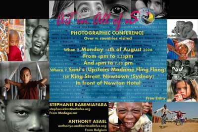
Tuesday, August 08, 2006
Art in All of us... in Sydney.
Supported by the UNICEF, Art in All of Us is a project aiming to create cultural exchange between every 192 UN countries using Art (photos, poems and drawings). Focussing on children as they are considered half a person in some countries. At the end of they journey, the 2 photographers will publish a book showing for each single country a photo of a child and a poem.
They visited already 90 countries.
Visit http://www.ARTinALLofUS.org
Conference>
monday 14/08
Venue: Soni's Newtown, 169 king street, upstairs at Madame Fling Flong.
Session 1 : 4.00 to 5.30 pm
Session 2 : 6.00 to 7.30 pm
They visited already 90 countries.
Visit http://www.ARTinALLofUS.org
Conference>
monday 14/08
Venue: Soni's Newtown, 169 king street, upstairs at Madame Fling Flong.
Session 1 : 4.00 to 5.30 pm
Session 2 : 6.00 to 7.30 pm

Friday, June 23, 2006
Training...
ENG: I've been training (walking) in the mountaineous area of Canberra during the past 3 days.
On the second day I got caught by a thick fog on the 3rd summit of the day, got lost (walk with no track at all). I only had 2 options:
1/stay during the night with almost no food and water, no sleeping bag anor tent.
2/take my compass and follow the best direction on instinct and try to find a road down.
I followed 2 and reached by my car after 3 hours of struggling going down a 50% slope full of rocks, heavy grass and trees.
FRA: J'ai ete m'entrainer a la marche dans la region montagneuse de Canberra pendant 3 jours. Le 2e jour, au 3e sommet de la journee, le brouillard epais empecha toute visibilite et je me suis perdu (rando sans balisage).J'abvais 2 options:
1/passer la nuit en montagne sans sac de couchage ni tente, peu d'eau et peu de vivres
2/ foncer a l'azimut et descendre dans une direction me s'eblant la plus ideale pour tomber sur une route.
J'ai choise la "2" et j'ai retrouve ma voiture de location apres 3 heures de bataille avec une pente a 50%, de la caillasse, des herbes hautes et arbres.
Monday, May 15, 2006
Winter time.
FRA: L'hiver approche, je continu a cherhcher du travail, ce qui n'est pas evident, j'ai eu des baisses de moral. J'essaye de m'entrainer un peu egalement a augmenter mon poids et solifier mes muscles et tendons.
J'ai assiste au BANFF Mountain movie festival tour, le meilleur des filmes d'aventure, a Sydney comme en 2004. ce fut un moment pour apprendre ce qui plait au public afin de pouvoir y proposer un film j'espere en 2007.
ENG: Winter is coming, it gets cooler. I'm still looking for a job, which is not easy. I lost motivation at times. I try too train and strenghten my muscles and tendons while getting more weight.
I'd like to enter my fiest movie in 2007 at the BANFF Mountain movie festival. Therefore I attended the tour of the best movies in Sydney, ilkeI did in 2004.
Sunday, April 30, 2006
The Mountains of the Outback
FRA: J'ai termine mon projet de petit film d'aventure au centre de l'Australie. Tous le détails sur le site web dans la partie PROJETS puis cliquez LARAPINTA.
ENG: I finished my small adventure movie project in the center of Australia. All details on my webste in the PROJECT section, then click LARAPINTA.
ENG: I finished my small adventure movie project in the center of Australia. All details on my webste in the PROJECT section, then click LARAPINTA.